Vulnerability to pedestrian trauma: Demographic, temporal, societal, geographic, and environmental factors
Issue: BCMJ,
vol. 52 , No. 3 , April 2010 ,
Pages 136-143 Clinical Articles
Background: Pedestrian trauma frequently results in devastating and costly injuries and accounts for 11% of all road-user fatalities. Trauma surgeons, with their unique perspectives on and access to injury data, and geographers, with their access to powerful spatial analysis tools, are in a strong position to help in the development of relevant and evidence-based policy for the prevention of pedestrian trauma.
Methods: A 5-year retrospective cohort study (2001 to 2006) was conducted in a large metropolitan region to determine demographic, temporal, societal, geographic, and environmental risk factors for pedestrian trauma.
Results: A total of 387 patients sustained severe injuries as a result of pedestrian trauma during the study period. Fifty-five percent (214/387) were male and the mean age of all patients was 54.0 years (range 18.0–98.0; SD 20.0). Most injuries tended to occur in the early evening and during the fall months (September to November). Inhabitants of lower socioeconomic status neighborhoods were particularly vulnerable and incidents appeared to cluster in high-risk locations.
Conclusions: Combined epidemiological and geospatial analyses can provide insights into a broad array of risk factors for pedestrian trauma. Spatial epidemiology may also have applications for other public health issues with complex determinants.
Ongoing epidemiological and geospatial surveillance can provide data for formulating injury-prevention policy.
Background
The consequences of motor vehicle crashes involving pedestrians are devastating. Canadian injury statistics from 1992 to 2001 reveal a yearly average of 416 fatalities and 14 252 injuries from pedestrian trauma (PT).[1] Many of these injuries are complex and require prolonged multidisciplinary care and rehabilitation, and result in significant loss of productivity.
The specific medical cost per PT patient in Canada has not been published, but an Australian group found that pedestrian injuries had a much higher average direct medical cost than injuries sustained by any other motor vehicle crash group.[2] Although public health efforts have resulted in significant advances in the reduction of injuries and fatalities,[1,3] the rates of PT remain high and the consequences are seen in emergency departments every day.
Further reductions in the incidence of PT may depend on more sophisticated insights into the determinants of PT. According to William Haddon, whose pioneering work has guided the science of injury prevention, aspects of the physical and social environments interact over time with the Host (person at risk), and the Agent (energy transmitted to the Host during an accident) to create injury risk.[4]
Prevention of injury may require modification of one or more of the many interactions that lead to this heightened risk.[5] It follows that a more detailed understanding of the predictors of injury risk will suggest options for injury control. Partnerships between front-line trauma care providers with detailed knowledge of injury data, and geographers with detailed understanding of our social and physical environments, may increase our capacity to identify (and modify) specific risks.
In this study, rigorous population-based epidemiology and geographic information science (GIS) methods were combined to characterize the spatial and societal context of pedestrian injury in a large urban region. We hypothesized that demographic, temporal, societal, geographic, and environmental factors are associated with vulnerability to pedestrian injury, and that careful analysis of these factors can help to guide the development of effective injury-prevention policy.
Methods
Metro Vancouver is a partnership of 21 municipalities and one electoral area with a combined population of over 2 million (www.metrovancouver.org).
The region is a large and diverse urban area with high population density and large traffic volumes, and an integrated system of trauma triage and treatment. Although there are numerous hospitals in the area, severely injured patients are, for the most part, transported to one of four trauma receiving facilities: the Vancouver General Hospital, the Royal Columbian Hospital, Lions Gate Hospital, and St. Paul’s Hospital. Data from patients admitted to any of these hospitals with severe injuries are included in the British Columbia Trauma Registry (BCTR).
The study cohort was considered to be all adults 18 years and older with home addresses within the boundaries of Metro Vancouver. Age and sex of study subjects, time and location of incidents, and socioeconomic status (SES) of neighborhoods in the region were derived from the BCTR and census data.
The outcome of interest (pedestrian trauma) was identified using both the BCTR data on patients with Metro Vancouver addresses who were admitted to trauma hospitals between 1 January 2001 and 1 December 2006, and ICD-10 codes for an admission diagnosis of PT. Patients were deemed to have severe injuries if they had an Injury Severity Score (ISS) of 12 or higher, or if they required a hospital stay of 2 days or longer.
Population-based epidemiology
Few studies in the literature have used strict population-based methods to measure incidence rates.[6] However, the data available for Metro Vancouver—information on a relatively fixed reference cohort and nearly complete capture of severe injuries from pedestrian trauma—were ideal for the determination of population-based estimates of pedestrian trauma.
PT incidence rates were defined as the ratio of PT incidents and the person-years at risk during the study period. PT cases (numerator data) were taken from BCTR trauma admissions records and compared with 2001 national census figures (denominator data). Incidence rates of PT were calculated for demographic and societal categories and for each of Metro Vancouver’s municipalities.
Spatial analysis
Analyses of the impact of societal and geographic determinants on PT risk were made possible through applications of GIS methods. The Vancouver Area Neighborhood Deprivation Index (VANDIX),[7] developed by the authors to integrate census-derived societal determinants of health (including income, education, and family composition), was used to stratify neighborhoods across Metro Vancouver.
This neighborhood stratification was done at the dissemination area (DA) level: the DA is a small, relatively stable geographic unit composed of one or more blocks. It is the smallest standard geographic area for which all census data are disseminated. DAs cover all of Canada (www.statcan.ca).
ArcGIS software was used to map individual and aggregate cases of PT, both by patient residence (to determine the effect of societal factors on injury risk) and by the actual location of the injury itself (to determine geographic clustering of injuries). The incident location data obtained from the BCTR was often not precise (e.g., only an intersection or a street name was provided) and manual mapping was required to locate many incidents.
The Clinical Research Ethics Board at the University of British Columbia approved this study. Individual privacy was maintained in the spatial analyses by aggregating data across the years of the study.
Results
Between 2001 and 2006, the BCTR recorded data on 7475 patients. A total of 3591 trauma patients had home postal codes within Metro Vancouver and 387 of these experienced PT.
In 2001, Statistics Canada determined the population of BC to be 3907738 and the population of Metro Vancouver to be 1986965. The BC incidence rate of pedestrian trauma was 3.2 per 100000 person-years. The Metro Vancouver incidence rate of pedestrian trauma was slightly higher at 3.9 per 100 000 person-years (Table 1).
Fifty-five percent of pedestrian trauma patients in the Metro Vancouver were male (214/387). The mean age of pedestrians was 54.0 (range 18.0–98.0; SD 20.0). Senior citizens (age =65) had more than double the incidence rate of PT than younger residents of Metro Vancouver. The average ISS in this group was 28 (range 13 to 75; SD 12.7).
Temporal factors
The time of day during which the incidents occurred was not recorded in 8% of cases. For the remainder of incidents, the greatest proportion of events (24.8%) occurred in the late afternoon, between 4:01 p.m. and 8:00 p.m. (16:01 to 20:00). PT events were most common during the dark and rainy time of the year: 29% of incidents occurred during the winter (December, January, February), and 33% occurred during the fall (September, October, November) (Figure 1).
Spatial epidemiology of pedestrian trauma
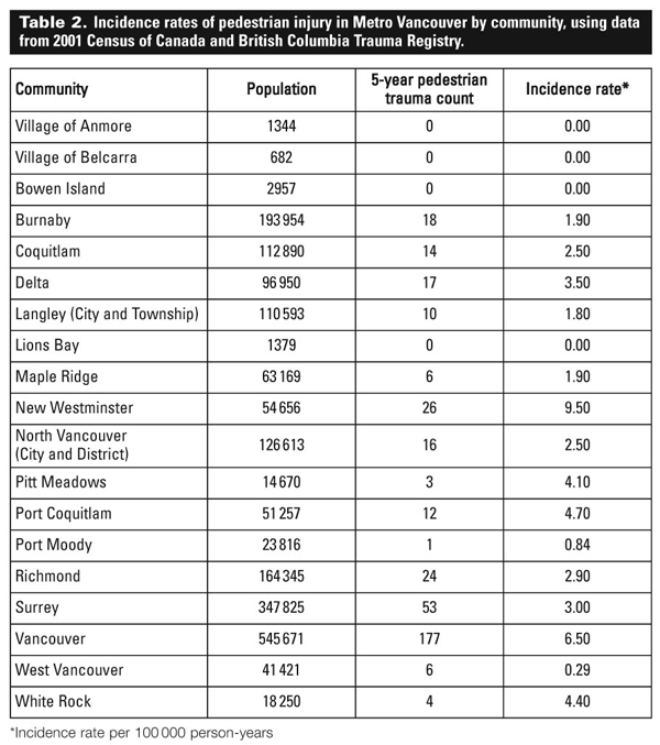
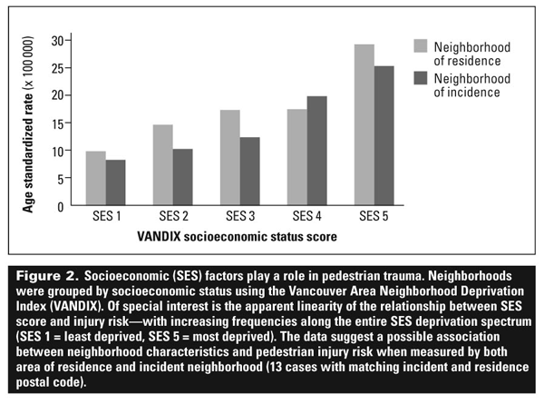
For the communities that make up Metro Vancouver, incidence rates of PT ranged from 0.00 to 9.50 per 100000 person-years (Table 2). Increasing neighborhood socioeconomic deprivation, as measured by the census-derived VANDIX score, was associated with increased risk of pedestrian trauma (Figure 2).
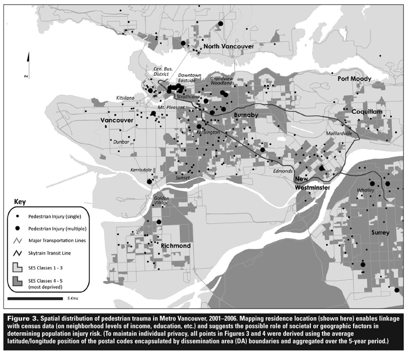
Residence location was mapped in aggregate to further delineate high-risk neighborhoods (Figure 3). Injury clusters are clearly visible in the Downtown East Side and central business district of Vancouver, as well as the Whalley region in Surrey and in New Westminster.
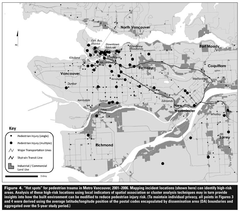
Where incident locations were available, these were mapped as well to determine whether high-risk streets and intersections could be identified (Figure 4). Discreet injury “hot spots” are seen throughout Vancouver, Richmond, and Surrey.
Analysis on a small scale reveals a high-risk corridor (East Hastings Street) to the east of downtown, with numerous clusters of multiple PT events.
Conclusions
In addition to providing insights into individual characteristics that may increase risk of pedestrian trauma, epidemiological and geographic analyses permit detailed and neighborhood-specific assessments of the social and physical environments of populations and may suggest avenues for injury prevention.
For example, numerous studies of adults have found that individual characteristics such as gender, age, education, ethnicity, and alcohol consumption are associated with pedestrian trauma risk.[8-10] But individual characteristics and behaviors only represent part of the context of injury risk.
Environmental determinants of pedestrian trauma
The social and the physical environment have both been found to contribute to pedestrian trauma.
In terms of the social environment, studies have revealed a host of socioeconomic factors demonstrating a significant association with the occurrence of PT. Demographic characteristics with a positive association with pedestrian injury include population density,[8,11,12] the number of families per residence,[13] household crowding,[14] low income or greater poverty,[8,14] fewer high-income households,[8] unemployment,[8,14] age,[12] and a higher proportion of youth.[8,12,14]
A higher proportion of males in the local population also contributes to a higher risk of pedestrian injury.[12] Our analysis, which demonstrates increased risk of injury with increased deprivation (based on a validated, census-derived composite measure of socioeconomic status), supports the observations of other investigators that vulnerabilities in injury risk continue to exist.
In terms of the physical environment, high traffic flow has consistently been found to be a substantial high-risk factor affecting the occurrence of pedestrian injury,[8,11,14,15] especially when the street width is greater.[15]
Other high-risk environmental factors include high cross-street densities,[12] invasion of pedestrian space by cars and vendors,[15] incomplete sidewalks and high crosswalk density,[16,17] higher proportion of multifamily residences, more curbside parking, and higher vehicle speeds.[14]
Braddock and colleagues,[11] used GIS to further explore the relationship between child pedestrian trauma and other built environment factors, including the location of schools, parks, playgrounds, and convenience stores. LaScala and colleagues[14] demonstrated the importance of school location as a geographic component of child pedestrian injury risk.
The location of retail alcohol outlets and density of bars have also been associated with pedestrian injuries.[10,14] Lightstone and colleagues[13] suggested that pedestrian injury sites identified as hot spots through GIS analysis can provide focal points for detailed fieldwork analysis. These types of studies hold the promise of identifying neighborhood-level risks, that, when combined with local knowledge, can inform effective prevention measures.
Our study continues in this tradition of systematic evaluation of the social and physical environments by combining trauma registry data with GIS data. GIS is a relatively new discipline in which investigators capture, store, analyze, and manage data and other associated attributes that can be spatially referenced to the Earth.
It has been applied in public health studies in a variety of ways, including the prediction of pathogen dissemination, the assessment of environmental effects on health, and the determination of population access to emergency and health services.[18]
Pedestrian trauma researchers have begun to employ a GIS approach, and simple applications have succeeded in plotting, or “geocoding,” crash locations and creating spatial representations of locations that identify different types of crashes.[17]
GIS has great analytical potential for public health issues in general, but this has not been fully exploited in the study of pedestrian trauma.[17] Further applications would allow accurate measures of the impact of various societal, environmental, and geographic factors on pedestrian injury risk or fatality.
Advantages of real-time geospatial surveillance
To be useful to injury-control efforts, detailed measures of the environmental context of injury may need to be done in a frequent and iterative fashion. In this way, new risks can be identified and the effects of new interventions can be measured. For example, despite the high frequency of PT in Metro Vancouver, the last detailed evaluation of PT was done nearly 20 years ago.[19]
Examining data from patients admitted to Vancouver’s two major hospitals in 1986, Vestrup and Reid[19] found that females were involved in pedestrian injuries in 60% of cases, and that elderly females were more likely to require hospital admission.
Like us, Vestrup and Reid also discovered that most pedestrian crashes occurred September through December, that crashes were most common from approximately noon to 8:00 p.m., that drivers were most often at fault, and that alcohol consumption was often a factor.[19]
The mean ISS of pedestrians injured in Vancouver in 1986 was 14.6 compared with a mean of 28 in 2001 to 2006. In light of their findings, Vestrup and Reid proposed that elderly persons and drivers be targeted for education. However, the extended gap between their analysis and ours means that the effects of these recommendations have not been tested.
Besides providing more frequent snapshots of injury risk in a city, the advantage of ongoing geospatial surveillance is that results can be communicated to policymakers and citizens in a readily understandable and reproducible way using current data and injury maps such as those presented here.
Our hope is to use the strategies we describe to continue integrating trauma, census, and geospatial data in a publicly accessible and user-friendly format so that risk can be communicated to relevant stakeholders in real time.
Study limitations
Because our data source was the BCTR, only patients with an ISS of 12 or greater, or those admitted to hospital for at least 2 days could be studied. Unfortunately, data about patients with minor injuries seen in emergency departments and clinics or admitted to hospital for very short periods could not be captured.[20]
Also, the use of retrospective data gives a limited view of social and environmental risks, and future surveillance efforts may require prospective data collection, including data from patient surveys and scene evaluations.
Future directions
This study represents the beginning of an in-depth evaluation of a complex public health issue. In future, data on socioeconomic risks can be used to focus education efforts and target them to high-risk neighborhoods. Incident location data identifying injury hot spots can be used to guide analyses of the built environment in these areas, which may uncover modifiable, community-specific aspects of the physical environment that confer injury risk.
Ongoing epidemiological and geospatial surveillance could provide a means for rapid and easily understandable communication of injury data for the formulation and evaluation of injury-prevention policy.
Effective communication, a critical next step in this surveillance strategy, will likely employ a web site for the presentation of key findings and sharing of information among grassroots and policy level injury-control organizations, local health authorities, and governments.
Future analyses will account for and evaluate injury-control measures already in place, and will find applications for injury-control measures that have been shown to be effective in other jurisdictions.
Acknowledgments
This project has been supported by a grant from the Michael Smith Foundation for Health Research. A portion of this project was presented at the Trauma Association of Canada annual meeting in Ottawa in 2007. The authors are indebted to the British Columbia Trauma Registry for its support and expertise.
Competing interests
None declared.
References
1. Transport Canada. Pedestrian fatalities and injuries, 1992-2001. www.tc.gc.ca/eng/roadsafety/tp-tp2436-rs200401-menu-165.htm (accessed 15 February 2010).
2. Hendrie D, Rosman DL, Harris AH. Hospital inpatient costs resulting from road crashes in Western Australia. Aust J Public Health 1994;18:380-388.
3. Transport Canada. Pedestrian fatalities and injuries, 1988–1997. Fact Sheet #RS2001-01, February 2001.
4. Rivara FP, Grossman DC, Cummings P. Injury prevention: First of two parts. N Engl J Med. 1997;337:543-548.
5. The National Committee for Injury Prevention and Control. Injury prevention: Meeting the challenge. Am J Prev Med. 1989;5(suppl):1-303.
6. Laupland KB, Kortbeek JB, Findlay C, et al. A population-based assessment of major trauma in a large Canadian region. Am J Surg 2005;189:571-575.
7. Bell N, Schuurman N, Hayes MV. Using GIS-based methods of multicriteria analysis to construct socio-economic deprivation indices. Int J Health Geogr 2007;14:17.
8. LaScala EA, Gerber D, Grunewald PJ. Demographic and environmental correlates of pedestrian injury collisions: A spatial analysis. Accid Anal Prev 2000;32:651-658.
9. Plurad D, Demetriades D, Gruzinski G, et al. Pedestrian injuries: The association of alcohol consumption with the type and severity of injuries and outcomes. J Am Coll Surg 2006;202:919-927.
10. Small TJ, Sheedy JM, Grabs AJ. Cost, demographics and injury profile of adult pedestrian trauma in inner Sydney. ANZ J Surg 2006;76:43-47.
11. Braddock M, Lapidus G, Cromley E, et al. Using a geographic information system to understand child pedestrian injury. Am J Public Health 1994;84:1158-1161.
12. LaScala EA, Johnson FW, Grunewald PJ. Neighborhood characteristics of alcohol-related pedestrian injury collisions: A geostatistical analysis. Prev Sci 2001;2:123-134.
13. Lightstone AS, Dhillon PK, Peek-Asa C, et al. A geographic analysis of motor vehicle collisions with child pedestrians in Long Beach, California: Comparing intersection and midblock incident locations. Inj Prev 2001;7:155-160.
14. LaScala EA, Grunewald PJ, Johnson FW. An ecological study of the locations of schools and child pedestrian injury collisions. Accid Anal Prev 2004;36:569-176.
15. Hijar M, Trostle J, Bronfman M. Pedestrian injuries in Mexico: A multi-method approach. Soc Sci Med 2003;57:2149-2159.
16. Schneider RJ, Khattak AJ, Zegeer CV. Method of improving pedestrian safety proactively with Geographic Information Systems: Example from a college campus. Transportation Research Record. 2001;1773:94-107.
17. Schneider RJ, Ryznar RM, Khattak AJ. An accident waiting to happen: A spatial approach to proactive pedestrian planning. Accid Anal Prev 2004;36:193-211.
18. Schuurman N, Bell N, Hameed SM, et al. A model for identifying and ranking need for trauma service in nonmetropolitan regions based on injury risk and access to services. J Trauma 2008;65:54-62.
19. Vestrup JA, Reid JD. A profile of urban adult pedestrian trauma. J Trauma 1989;29:741-745.
20. Goris RJ. The injury severity score. World J Surg 1983;7:12-18.
Dr Lord is a resident in the Department of Surgery at the University of British Columbia (UBC). Dr Hameed is an assistant professor in the Department of Surgery at UBC. Dr Schuurman is a professor in the Geography Department at Simon Fraser University. Dr Bell is a postdoctoral fellow in the Department of Surgery at UBC. Dr Simons is an associate professor of surgery at UBC.